![]()
NORR Architecture and Engineering is a Toronto-based company that was tasked with a revamp project of the E-wing at Mohawk College. NORR collaborated with Unmanned & Remote Sensing Innovation Centre (URSIC) to use Remotely Piloted Aircraft (RPA) technology and generate wholistic scans of the E-Wing.

Research Area: Unmanned & Remote Sensing
Research Team: Richard Borger, Matthew Shelley, James Kretz
Future Ready Challenge
Architects and engineers are often tasked with updating existing buildings, from public buildings such as libraries or government centers, to campuses and multi-use sites. Integrating existing structures with new design concepts can be a challenge. As design teams progress from conceptual drawings into increasingly precise schematics and blueprints, they require precise, geographically-accurate data to properly tie new designs into existing features.
R & D Collaboration
In 2020, Mohawk College embarked on an extensive revitalization of E Wing at the Fennell Campus. Since E Wing is the central part of the main Fennell Campus buildings, the revitalization would entail interactions with several other wings.
Toronto-based NORR Architecture & Engineering Firm had developed an intricate plan for E Wing’s updated façade, which tied into the college’s C Wing, EA Wing, and G Wing.
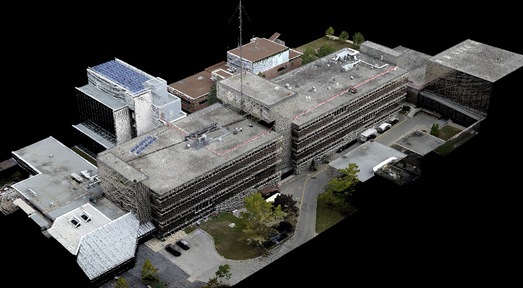
NORR initially planned to complete localized terrestrial LiDAR scans of the areas where the wings met, providing them with a highly accurate geometric model of the areas of interaction. However, this approach would have resulted in three disconnected scans that only included the areas of interaction, with nothing connecting them together. Faculty and students at Mohawk’s Unmanned and Remote Sensing Innovation Center (URSIC) saw an opportunity to use Remotely Piloted Aircraft (RPA) technology to offer more comprehensive data.
Innovative Results
URSIC proposed completing a full aerial scan of the Fennell Campus, coupled with high-resolution terrestrial LiDAR scan of the areas of interaction. Since an aerial scan would provide a geometrically accurate plan of the campus, the terrestrial scans could be meshed with the aerial scan to provide a complete digital twin of both the specific areas of interest along with an accurate view of how these areas were connected across the E-wing as a whole.
The URSIC team used a DJI M600 RPA, equipped with a Phoenix Scout-32E LiDAR, to scan the Fennell Campus using a grid pattern. When scanning this way, the images are captured almost perpendicular to the ground, and the resulting digital twin offers high accuracy and geolocation for horizontal surfaces. As expected, the walls of the campus buildings were largely skeletal, creating an ideal frame for “hanging” the terrestrial scans of the areas of interaction.
To capture accurate data for the areas of interaction between E Wing, C Wing, EA Wing, and G Wing, URSIC used the Leica P20 to take high resolution scans of each area of interest. The terrestrial scans were then meshed with the aerial scans, creating one geometric model of E-wing. The combination of aerial and terrestrial data created an accurate, geolocated model for the NORR team. This was one of the first times NORR was able to utilize aerial scanning to compliment their terrestrial scans.
“URSIC offered a significant practical experience for students and faculty, and utilize in-house skills and technology to reduce project costs for the E Wing Revitalization Project,” stated Julia Hansen, Director of Strategy and Interprofessional Learning at Mohawk College. “It was an excellent opportunity for our students to gain real-world experience using current technology in an innovative way.”
“This was a great demonstration project and learning opportunity for students, though we had some trepidation about how useful the exercise was going to turn out for us. We need not have been concerned; the experience was like working with any other external professional consultant,” said David Clusiau Vice President Design NORR Architects and Engineers. “The URSIC work provided the accurate existing building information we needed to refine our design and ensure that we had considered and incorporated all the external variations in our concept. We would not hesitate to work with them again.”
Click here to view a model of the Fennell Campus.
