Unmanned and Remote Sensing Innovation Centre

Two individuals flying a drone

Mohawk Ideaworks Logo

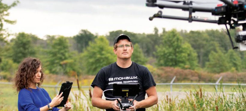
Remote sensing using remotely piloted aerial systems, rovers, and unmanned boats, is emerging as a rapid and cost-effective tool for exploration and inspection in sectors as diverse as energy and utilities, manufacturing, agriculture, transportation, and security. 

Experts at Mohawk’s Unmanned and Remote Sensing Innovation Centre (URSIC) work closely with the private sector, public services, and municipalities to accelerate the adoption of remote sensing technology. With access to a comprehensive suite of specialized equipment, URSIC can help de-mystify and de-risk the technology. The centre aims to help organizations explore how remote sensing can effectively collect high-quality data, support comprehensive remote monitoring and visualization of critical infrastructure, and increase the efficiency in overall workflow while reducing health and safety risk to personnel. 

Services

Learn how we can help you test and adopt the latest innovative technology in the field.

Get Started

Remote inspection & data collection

New innovations in unmanned and remote sensing technology allow for targeted data collection in areas that are hazardous to access or expensive to monitor on a routine basis. Even if you have used remotely piloted sensing systems in the past, new advancements in sensor and platform technologies allow for new data collection opportunities, such as drone-mounted and RPAS-mounted sonar, which can be used to for bathymetric inspections of hard-to-reach waterways. 


Whether your asset is a bridge, a road, a new building, or a dam, the URSIC applied research team can help organizations test numerous innovative approaches for remote inspection on land, over water, and in the air, and support the development of high-resolution data visualization models.

Remote sensing exploration & adoption

The use cases for remote sensing are extensive: the technology can be used to develop high-resolution LiDAR models of critical manufacturing assets for engineering applications, undertake remote and autonomous monitoring of hazardous environments, and test innovative solutions to product delivery.

However, it can be difficult to know which technology works best for your organization, what platforms to invest in, and how to build your remote sensing team. It is also important to understand and comply with the legislation, certifications, and regulations that govern remotely-piloted aircraft system flights.
 

With applied research, the experts at URSIC can help you explore multiple unmanned and remote sensing technologies, while ensuring operations comply with all Transport Canada and NavCan regulations. 

Security applications

The range and flexibility of remotely piloted aircraft systems can help quickly detect threats, support remote monitoring of large geographic areas, ensure security of critical assets, and collect real-time footage. Remote sensing technology can also be used by organizations to prevent unauthorized threats and incursions by humans, or other remotely piloted aircraft systems.
 

URSIC can partner with law enforcement or corporate security teams to validate use of the technology in multiple cases, such as remote monitoring of critical infrastructure in isolated locations, crowd monitoring at live events, or the detection of evidence or forensic remains. 

Mapping

When using traditional surveying methods, mapping can be a time-consuming, expensive process. Unmanned and remote sensing technology can be used to conduct aerial and bathymetric surveys, making it easier and more cost-effective to collect data on a regular basis. Specialized technologies, such as RGB photography for photogrammetry, multispectral, thermal, and LiDAR sensors also allow for the quick collection of highly-accurate data. 


Leveraging URSIC’s expertise and extensive equipment listing in this field, URSIC can help companies generate large data sets, which offer unparalleled opportunities for industry to rapidly address challenges, including long-range inspection, resource mapping, and rapid response maintenance. 

Regulatory compliance and auditing

URSIC can advise its partners on regulatory compliance, providing procedure audit and review services. The centre also supports applications for Special Flight Operations Certificate (SFOC) TO Transport Canada, the government agency responsible for regulating aviation in Canada. Additionally, the centre helps partners implement standardized competency training and testing for pilots in accordance with the National Institute of Standards in Technology (NIST). 

Equipment

Our mobile research capabilities allow equipment to be used anywhere in Canada.

Get Started

Unmanned & remotely piloted systems

URSIC’s assets include a wide range of industry-leading unmanned and remotely-piloted aircraft systems, offering a wide range of capabilities to serve most industry-use cases, including visual line-of-sight (VLOS), and beyond visual line-of-sight operations (BVLOS). URSIC also has access to a national network of applied research partners and can source additional platforms as needed.

Scanning equipment used by the URSIC team include:

  • DJI Matrice M600, M300, M210
  • DJI Agras T10
  • Skydio 2+
  • DJI Mavic 2 (Enterprise & Zoom), Mavic Pro
  • DJI Phantom 4 Pro v2, Phantom 4 Pro
  • DJI FPV
  • Parrot Anafi
  • DJI Mini, Mini 2
  • Blue Vigil Tether
  • Parachute Recovery Systems: M300, M600
  • Full suite of micro drones for training
 

We also offer remotely-controlled terrestrial systems, such as terrestrial photogrammetry rovers.

Aerial & terrestrial LiDAR

Terrestrial laser scanning and airborne LiDAR allow for the detailed and accurate collection of data points from an area being scanned or mapped. Aerial and terrestrial LiDAR systems are used in conjunction with URSIC’s suite of RPAS and rovers. 

Aircraft systems (RPAS) equipment include:

  • Emesent Hovermap (SLAM)
  • Phoenix LiDAR Scout 32E
  • Leica P20 and Leica BLK 360
  • Pix4D viDoc (SLAM)

Remotely operated SONAR Systems

Sonar mapping allows us to create detailed elevation and terrain mapping of underwater environments. Our remotely-operated SONAR equipment include UgCS Echo Sounder, a drone-mounted sonar system, coupled with Hydromagic processing software. 

Aerial and Terrestrial Optics for Photogrammetry

Unmanned and remote sensing platforms can facilitate the collection of data to support the development of 2D and 3D models as well as digital twins. The technology provides a cost-effective and efficient way to collect photogrammetric data in lieu of surveys collected from manned-aviation. 

Aerial optics equipment include:

  • Zenmuse H20T
  • Zenmuse P1
  • Zenmuse XT2
  • Zenmuse Z30

Terrestrial optics equipment include:

  • Ricoh Theta Z1
  • Matterport
  • GoPro
  • DSLR Cameras

Registration and Visualization Software

To process the data collected from remote-sensing missions, URSIC's team has access to a wide range of software to view, collect, and analyze data for applied research projects. 

Here are some examples of the software we use: 

  • Adobe (Full Suite)
  • Autodesk (Full Suite)
  • Bentley Micro Station
  • DJI Terra
  • Leica Cyclone
  • Pix4D
  • Reality Capture
  • TerraSolid
  • UgCS Client

Richard Borger portrait.

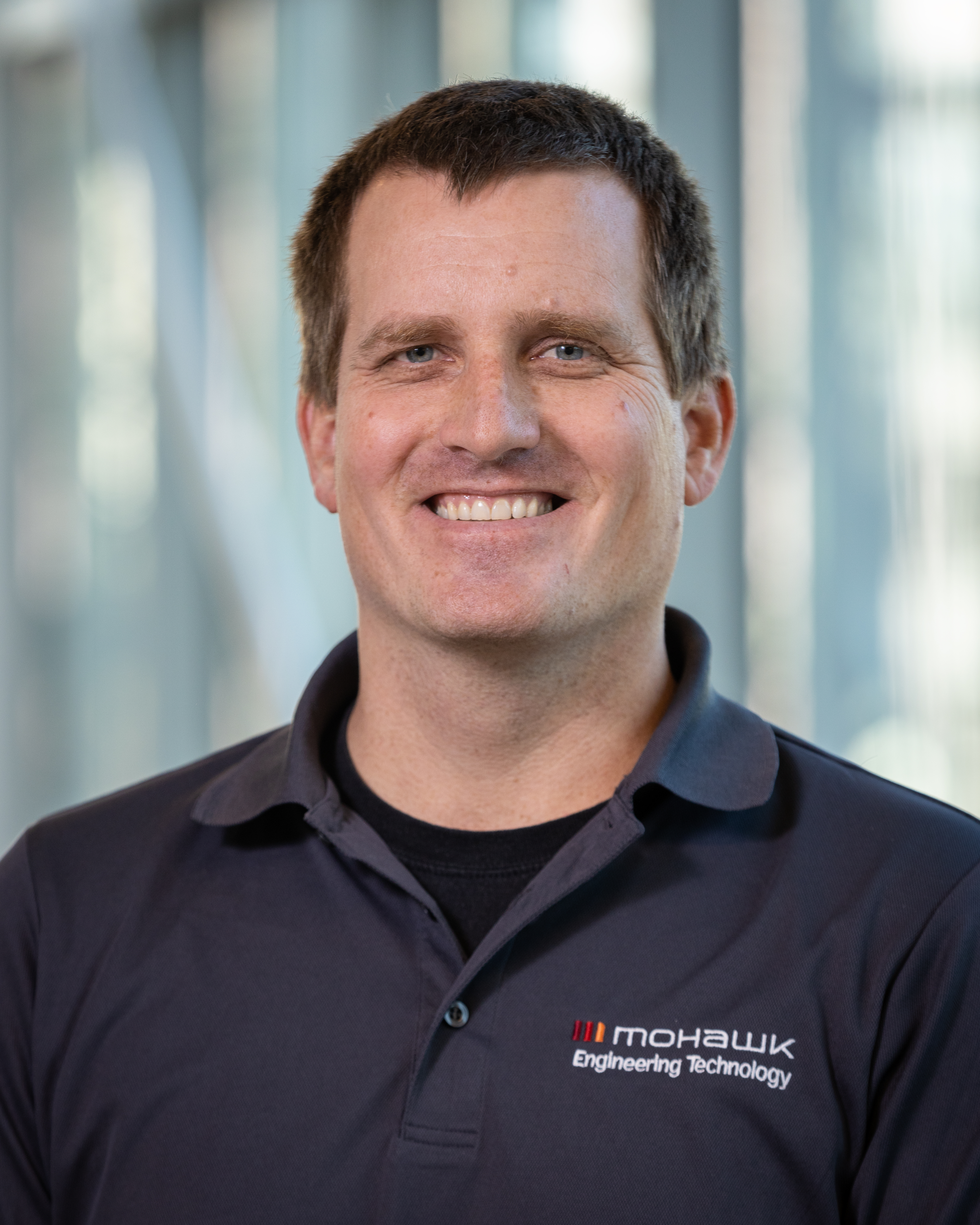
Richard Borger, Researcher and Professor

Richard Borger is a full-time faculty member in the Building and Construction Sciences program at Mohawk's School of Engineering Technology, as well as a lead researcher at the Unmanned and Remote Systems Innovation Centre. Under his leadership, Mohawk has completed more than 40 industry/academic projects that leverage new and emerging unmanned systems for remote sensing and data collection. Richard is recognized as one of the leading experts in this technology in Southern Ontario, with nearly 10-years of experience in RPAS, specializing in regulatory compliance and integration, LiDAR, and rapid response long-range remote sensing. He is fully trained and certified by Transport Canada to pilot remote and unmanned flights. He holds a Bachelor’s degree in Education from Brock University as well as two diplomas from Mohawk College- one in Materials Engineering Technology and the other in Mechanical Engineering Technology. 

richard.borger [at] mohawkcollege.ca (Contact Richard)   linkedin icon

Matt Shelley portrait.

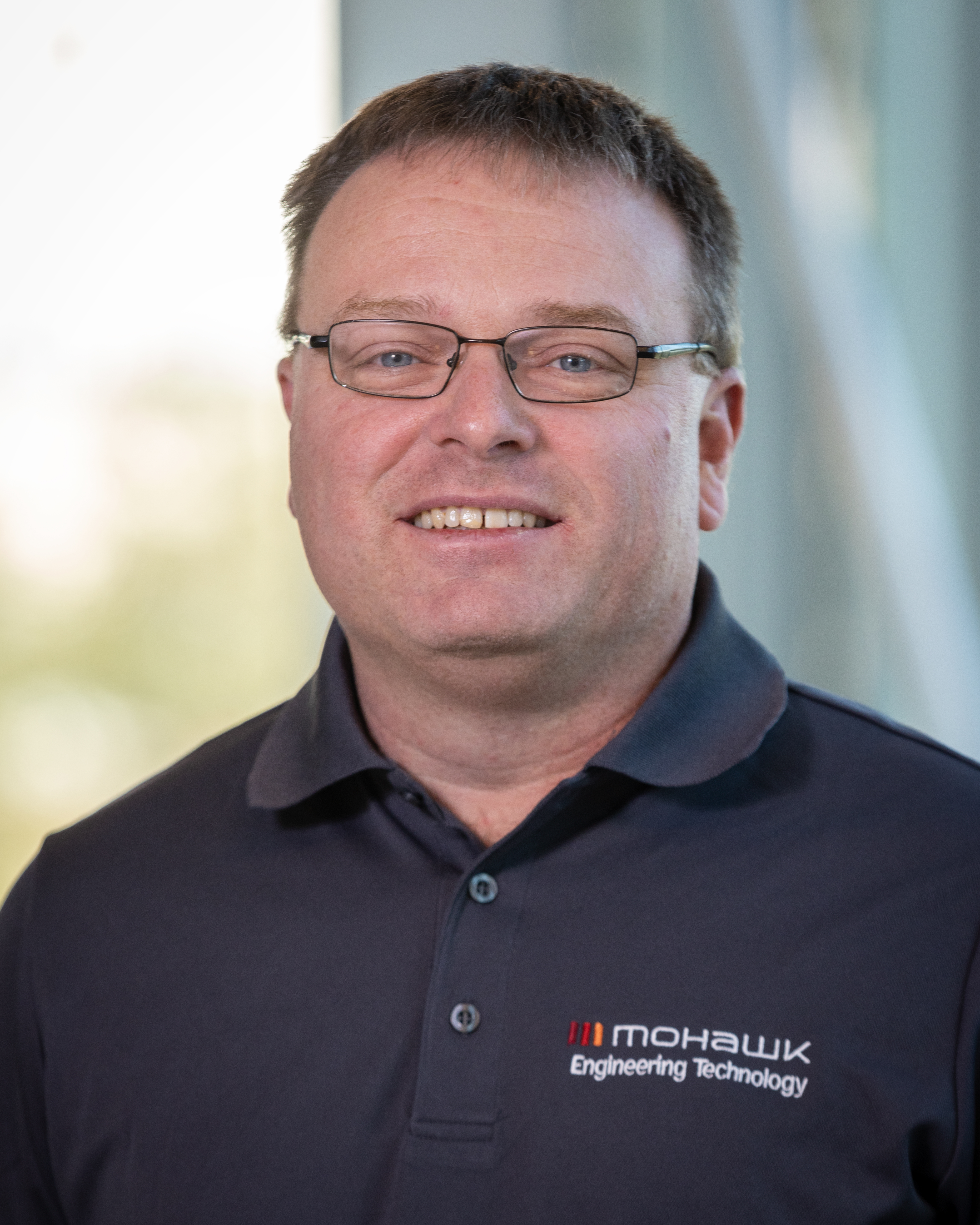
Matt Shelley, Researcher and Professor

Matt Shelley is a full-time faculty member at Mohawk College, as well as a researcher at the Unmanned and Remote Systems Innovation Centre. Matt has 10-years of experience in RPAS including flight operations and LiDAR scanning. With significant experience in overseeing and coordinating on-site flight operations and equipment usage, Matt has worked on over 40 different industry/academic projects. He is fully trained and certified by Transport Canada to pilot remote and unmanned flights. He holds a diploma in Civil Engineering from Mohawk College. 

matt.shelley [at] mohawkcollege.ca (Contact Matt)   linkedin icon

Ontario Power Generation

Ontario Power Generation

Mohawk College partnered with Ontario Power Generation partnered to utilize RPAS-mounted LiDAR to monitor and revitalize dam restoration projects by combating plant overgrowth.

Read more about OPG
Niagara Parks Logo

Niagara Parks Commission

Mohawk College recently worked with the Niagara Parks Commission to test the effectiveness of drone-mounted LIDAR technology as a tool to build 3D models to support building rehabilitation.

Learn more about Niagara Parks
Royal Botanical Gardens Logo

Royal Botanical Gardens

The Royal Botanical Gardens (RBG) has connected people to the plant world for over eight decades. RBG collaborated with the Unmanned and Remote Sensing Innovation Centre (URSIC) to experiment with strategic seeding using an aerial drone to prevent plant overgrowth in a hydro corridor.

Read more about the Royal Botanical Gardens
Garden City Display Fireworks Logo

Garden City Display Fireworks

Garden City Display Fireworks is ready to create the perfect pyrotechnic spectacle for any event. They collaborated with the Unmanned and Remote Sensing Innovation Centre (URSIC), to combine pyrotechnics and RPAs and create a dynamic and innovative show.

Learn more about the Garden City Display Fireworks
Construction Demathieu Bard Logo

Construction Demathieu Bard (CBD)

Construction Demathieu Bard (CDB) is a construction and engineering company that provides services in the fields of infrastructure, buildings, and industrial and tertiary facilities.

Read more about Construction Demathieu Bard (CBD)
Arcelor Mittal Logo

ArcelorMittal Dofasco and URSIC

ArcelorMittal employs approximately 168,000 employees in 60 countries. Flagship locations like ArcelorMittal Dofasco play a vital role in inventing smarter steels for a better world. Each year, they ship 4.5 million net tons of high-quality flat carbon steel. And they partner with the top automotive, energy, packaging and construction brands to develop lighter, stronger and more sustainable products – from cans to cars.

Learn more about ArcelorMittal Dofasco and URSIC

NORR Architecture and Engineering

Can Remotely-Piloted Aircraft (RPA) technology help provide accurate scans of building blueprints? NORR Architecture and Engineering worked with URSIC to use the technology in the design phase of the college's E-wing revamp project.

Learn more about NORR Architecture and Engineering
Ontario Power Generation logo on white background

Ontario Power Generation

The OPG asked URSIC to explore if drone equipped-LiDAR equipment could be used to complete a clearer visual inspection at its vegetation-covered Waba Dam facility.

Read more about OPG

Thank you to our funding partners

     Ontario Centre of Innovation Logo     NSERC CRSNG Logo     

About IDEAWORKS

URSIC is part of IDEAWORKS, Mohawk’s active hub of applied research and innovation. IDEAWORKS accelerates Canadian and global innovation by supporting industry access to expert researchers, specialized facilities and world-class technologies. 

X Logo  linkedin icon